Courel Mountains UNESCO Global Geopark (UGGp)
The Courel Mountains Geopark is the perfect place to observe the results of many phases of our planet’s geological history, specifically those of the lower and middle Paleozoic Era, and to a lesser degree, also the Late Tertiary and Quaternary periods.
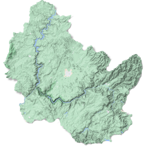
The Geopark covers an area of 577.85 km² in the eastern part of Ribeira Sacra, within the municipalities of Folgoso do Courel, Quiroga, and Ribas de Sil. It was added to the list of UNESCO Global Geoparks* in 2019.
The main element that supported this recognition was the important relationship existing in this territory between geology and human culture. The Courel Mountains Geopark contains a valuable geological heritage that includes rocks, minerals, fossils, geologic structures, and modern landscapes dominated by fluvial and glacial valleys, and the local residents have been finding ways to take advantage of these resources for more than 4,000 years.
All of this combines to produce a very rich geological environment. One of the most outstanding geological resources in the Courel Mountains Geopark is undoubtedly the Campodola-Leixazós fold. Declared as a Geological Point of International Interest in 1983, it is now considered to be not only one of the most significant points of structural geology in Spain, but in all of Europe as well. This is a type of natural phenomenon that can only be viewed in a very limited number of locations worldwide.
The Campodola-Leixazós fold allows us to see, in plain sight (this is unusual, because these formations are usually hidden below the surface), what has occurred beneath the earth’s crust during the last 500 million years. To facilitate observation of this feature and other geological phenomena, the Geopark has an extensive network of “geoviewpoints” (“geomiradores”), which can be seen on the map further below.
When the Romans entered into this territory, it opened up a new phase in terms of human exploitation of these geological resources. They developed settlements here for the purpose of extracting gold, and more than 100 Roman gold mining operations have been recorded in this area. Some of the works they created are still visible today, such as the mines at O Covallón and Margaride and the Montefurado Tunnel.
Later, they began to focus on extracting other minerals as well, such as iron ore. More recently, a significant metallurgy industry was developed in this area, with up to 15 blacksmithing operations (8 of these in the municipality of Quiroga). At the end of the 19th century, that industry began to decline, and mineral extraction became focused on other metals such as antimony and lead. In fact, one of Spain’s most important antimony mines, the Vilarbacú mine, is found in the Courel Mountains Geopark.
Most recently, extraction of other resources took on special relevance during the 20th century, such as slate and limestone (which is then processed to obtain lime).
You can discover the unique history of the Courel Mountains Geopark and the people who have lived and worked there at the Geological and Ethnographic museums in Quiroga, and at the Gold Mining Museum in Ribas de Sil.
* What is a Geopark? The Spanish Geoparks Forum defines a geopark as “a territory that contains unique geological heritage as well as its own strategy for development. It has clearly defined borders and sufficient surface area to generate its own economic development. Although geoparks can make a contribution to protecting geological heritage, they are not a means of geological protection and are not intended to be. The purpose of the geoparks is to improve quality of life for the local residents and acknowledge an area’s geological richness.”
 Interactive map