Directions
16.9.a Peares – Porto do Vao
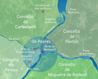
Although rivers have traditionally been used to mark boundaries between different territories, in a location such as Os Peares, where Galicia’s two main rivers come together, the Miño and the Sil, along with the smaller Búbal River, the situation can get complicated.
The fact that the town of Os Peares had become very economically prosperous also helps explain the expansion that took place along the banks of those three rivers in all directions. This has created a situation where a single town belongs to two different provinces (Lugo and Ourense), three judicial districts (Chantada, Monforte de Lemos, and Ourense), and four municipalities (A Peroxa, Carballedo, Nogueira de Ramuín, and Pantón).
These differences are more than just a curiosity, because they have given rise to many types of problems related to healthcare services, schools, telephone lines, and even package delivery.
Because of this, in 1999 the Os Peares Local Consortium was created by the various local governments, with the aim of facilitating these administrative tasks, coordinating investment, and establishing an urban planning system. This consortium now shares its headquarters with the local healthcare centre, in the modern white building we can see on the other side of the river.
This is the same location where the Os Peares riverside beach is found, which features a large swimming pool that makes use of water from the Búbal River, and which has become a popular location for summertime gatherings and recreation.