 Directions
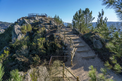
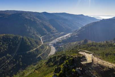
Alto da Picota Viewpoint - Os Peares

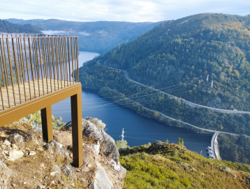
This viewpoint towers 429 metres above the Miño River and affords an unusual and impressive panoramic view of Os Peares.
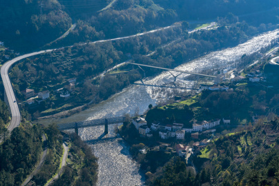
It gives a stunning panoramic view of the winding N-120, dam, village of Os Peares, the iconic blue railway bridge and the mouth of the rivers Sil and Búbal as they flow into the river Miño. This view also showcases the magnificent geological masterpiece known as the Sil Canyon and, on a clear day, even spot the Monastery of Santo Estevo de Ribas de Sil in the distance.
The viewpoint comprises two structures, one adapted for people with reduced mobility, a great observation deck overlooking the Os Peares dam.
The base of the viewpoint has a reserved spot for reduced-mobility visitors.

Detail. Source: Segredos de Pantón Cultural Association
- THE PLACE
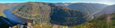
This nature observation deck is located in La Picota, in the parish of San Miguel de Oleiros, within the municipality of Carballedo.
This natural hill is located in the area around the Alto de la Picota, reaching a maximum height of 479.8 metres above sea level.
- THE ENVIRONMENT
|
Fast Facts |
|||
|
Surface area |
139.6 km2 |
|
|
|
Population |
2,080 |
||
|
Demonym |
Carballedesa/és |
||
|
Highest point |
1,114.2 masl |
||
|
Comarca |
Chantada |
||
|
Capital |
A Barrela |
||
|
No. of parishes |
24 freguesías (parishes) |
||
|
No. of population sites |
201 |
||
|
Bordering |
North |
Chantada |
|
|
South |
Vilamarín and A Peroxa |
||
|
West |
San Cristovo de Cea and Rodeiro |
||
|
East |
Pantón |
Escudo de Carballedo |
|

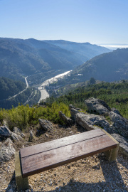
This spot in Carballedo provides a vantage point of different places, villages and towns.
The town Pantón lies straight ahead, with the parishes of San Vicente de Pombeiro and Santo Estevo de Atán, in the background and at the head of Pantón is Pena Pombeira (707 metres above sea level) and behind this mountain stands the majestic Cabeza de Meda, where the monastery of Santo Estevo housed its snow houses.
The left side provides a glimpse of the rest of the town of Carballedo. The riverside parish of San Xoán da Cova stands out.
The right side of the panorama comprises the famous Os Peares (4 parishes, 4 towns, 3 regions and 2 provinces). Further up and to the right is Nogueira de Ramuín, though it was simply called Nogueira before 1857, and the prominent monastery of Santo Estevo de Ribas de Sil.
The Cabeza de Meda towers in the distance (1,316 masl), where 3 towns converge (Montederramo, Parada de Sil and Xunqueira de Espadanedo). The setting of this mountain is always a reference point to mark the winter season, as it is the highest point in sight and the first to accumulate a beautiful snow cap.
- LEGENDS
The Pantones village of Bazal (San Vicente de Pombeiro) is located straight ahead. The people of this region fished frequently in the Miño River, and they tell an interesting story of a man from the village of Bazal...
One day, a villager from Bazal was fishing in the Miño, somewhere between Bazal and Vilamirón. There he spied a beautiful girl sitting and combing her hair on a boulder along the banks of the Miño River. They began to talk and the young girl told him that she was trapped in a spell affecting the Vilamirón castro (pre-Roman hillfort). She then said that if he helped her break it, she would make him very rich, and they would marry and be very happy together.
The man agreed to help, pledging to do whatever it took. The girl told him that he had to fill an entire plate with the hazelnuts of a certain hazelnut tree. Then he would have to break them one by one, throwing the shells into the river. She told him not to stop, no matter what happened. After getting the hazelnuts, he returned to the place where he had met her, but she was no longer there. He then began to chop the hazelnuts, but as he chopped the last one, the ground began to rumble and shake, and boulders broke off and fell into the flowing ‘Father Miño’. Even the high crag where he sat began to break up. He was confused and afraid. Suddenly a large bird emerged from amongst the boulders. It lifted him to a safe spot and then morphed into a beautiful girl. She then gave the fisherman all the riches of the Vilamirón hilltop.
- THE LAND AND ITS PEOPLE
There are two distinct features to this region: the riverside and the mountain.
The riverside comprises all the areas along significant waterways, particularly the Búbal, Cabe, Mao, Sil and Miño. This is where local communities developed the terraced farming structures and methods known as muras, socalcos and pataos. The riverside inhabitants cared for their orchards, meadows, fruit trees and, of course, vines. The Ribeiraos are outwardly very cheerful and fun people.
In Carballedo, the parishes of San Miguel de Oleiros, San Xoán de la Cueva, Santo Estevo de Chouzán and San Pedro del Erbedeiro all occupy the riverside area.
Heading up the hillside into the hinterland from the riverbank, we will meet the region’s mountain people, who worked the mountain for their trade, mostly livestock and grain cultivation. Some folks also had plots along the riverbank to grow produce not readily available in the mountains. They were known to be more frugal and thrifty, and, as the saying goes, chestnuts kept the mountains starving.
The remaining parishes of Carballedo in this municipality are mountain parishes.
This way of portraying the inhabitants of distinct geographical areas is kept in the tradition and memory of times gone by, when journeys were made on foot and the only way to stay warm was by playing a game of tip-cat, a sport using two wooden sticks known in Galicia in the region as Billarda.
If the mountains are now part of our common heritage and our riversides tended with vines, it all comes from the women and men born and raised here who had to overcome everything to survive.


 What would you improve?