
Cycle touring route Geographical centre of Galicia from Chantada

ATTENTION: The route is not signposted for bicycles. The use of GPS is recommended.
 Directions
 Linear route from Chantada that connects with the Geographic Center of Galicia in Antas de Ulla, running approximately half of the route in the Ribeira Sacra.
Without having high altitudes, it is a slightly demanding route due to the irregular orography of the area through which it runs and its always ascending route. Its 34 kilometers of length are distributed, practically 50%, between quiet asphalted tracks and others with natural road surface. Hence the technical difficulty is low.
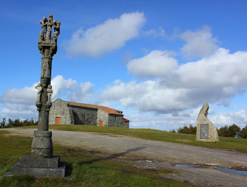
The environment through which it runs is located in the regions of Chantada, Deza and finally in A Ulloa. Just on the border of the first two, the route passes through Monte Faro where you can visit the Hermitage of Nosa Señora do Faro. It should be noted that the first kilometers share the route with the St.James Way, which is another added value to take into account and enriches the cyclist’s experience.
Paviment type: 4% road (1.37 km), 51% asphalted road (17.57 km), 30% non asphalted road (10.29 km), 15% paths and trails (5.05 km).
Elevation gain: 927 m
PDF road map here.

Ruta Cicloturista Centro Geográfico de Galicia desde Chantada
Equipment and Services

Accessibility


 What would you improve?