Directions
16.2 Belesar
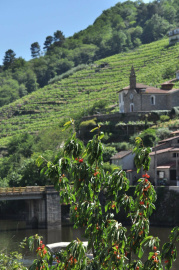
The Miño River acts as a natural border between the territories of Terra de Lemos and Chantada, and it must be crossed in order to travel between them. However, the mountainous topography made bridge construction difficult, so the Belesar bridge, of Roman origin, was the only one existing between Portomarín and Ourense until well into the 20th century. This is why Belesar has always been an important crossing point, and a place where two neighbourhoods came to exist, one on each side of the river, with each belonging to a different municipality.
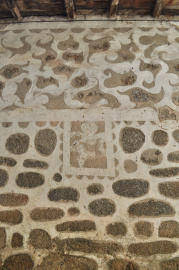
Here we can find good examples of the traditional architecture, with buildings made of stone and wood and adapted to the sloping contours of the land. Walking around the town, we can see excellent examples on some of the houses of the decorative technique known by the Italian term sgraffito (esgrafiado in Spanish). These are designs created by applying two contrasting layers of plaster, then scraping off the surface layer, which is generally a white lime plaster, to create geometric patterns, fanciful shapes, or even figures.
The houses are scattered among the cultivated stone terraces, with those closest to the town dedicated to vegetable gardens and the rest typically used for vineyards, with cherry trees mixed in as well. The cherries grown in Belesar have an especially good reputation and are featured at the Belesar Wine and Cherry Festival, which has taken place here since 2006 in late May or early June.
As previously explained, this is where the Romans had constructed their roads between Monforte and Chantada, with a very iconic section of their road still remaining, known as the Codos de Belesar (Belesar Curves). The original paving stones are still in place along this series of turns, which were created so that the road could climb the steep incline. This historic feature is found along the modern road that runs towards Belesar and then on to the 12th-century Church of San Paio de Diomondi, and it is also part of the Winter Route of the Way of St James.
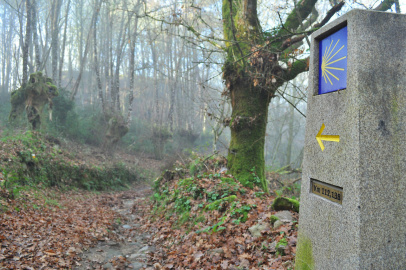
WINTER ROUTE
The Winter Route is one of the many alternative routes that head towards Santiago de Compostela along the Way of St James, and its name reflects the fact that it was often used during the winter, when it became difficult to follow the French Route through the snow-covered mountains of Os Ancares and O Cebreiro. Those conditions caused some pilgrims to look for a better route further to the south, which they found by following the course of the Sil River after reaching Ponferrada.
The Winter Route enters Galicia at Valdeorras, then crosses Ribeira Sacra through the municipalities of Quiroga, Ribas de Sil, A Pobra do Brollón, Monforte de Lemos, Pantón, O Saviñao, and Chantada.
Here at this point, one of the most difficult portions of that route begins just after the slope traversed by the Codos de Belesar, as the path gains elevation until reaching the town of Chantada, then continues upwards towards Faro Mountain, eventually reaching an altitude of 1,187 metres.